North Carolina is one of the nation’s boating gems. Its unusual variety of boating conditions makes boating enjoyable, and its boating-friendly culture means you’ll feel welcome in every coastal town.
The Tarheel State is home to many charming small towns that welcome cruising boaters as guests. Dinghy docks and free town docks are more common here than in other states. Rural areas have beautiful gunkholing spots. While the land is low, wild, and marshy, it’s also beautiful. There’s tons of bird and fish life. And, whatever the reason, North Carolina has the best sunsets on the ICW.

Here’s a look at the boating conditions you can expect to find while cruising coastal North Carolina, from the Outer Banks to the sandy beaches of the Grand Strand.
North Carolina Boating Overview
North Carolina is a state of geographic contrasts, from the towering Blue Ridge Mountains in the west to the flat coastal marshes and dunes in the east. But boating in the state is just as varied. You could spend many happy months wandering around the sounds and rivers of Eastern North Carolina and feel totally surprised and refreshed when you arrive at the sandy beaches along the coastal areas.
You can boat far up big rivers to discover some big downs. Imagine docking your boat on the Cape Fear River, right in the chic downtown area of Wilmington, walking to explore all the bars and restaurants. Or, cruising just 20 miles up the Neuse River to the small city of New Bern, North Carolina’s first capital city. Then there are towns like Southport, Beaufort, Little Washington, Belhaven, and Elizabeth City. A more charming collection of welcoming waterfront towns you won’t find anywhere.


North Carolina Cruising Conditions
In addition to the waters of the Atlantic offshore (including the legendary “Graveyard of the Atlantic” off Cape Hatteras), North Carolina can be divided into three cruising regions: the Sounds and Rivers, Outer Banks, and coastal Intracoastal Waterway.
Boating on North Carolina Sounds and Rivers (aka the Inner Banks)
The sounds and rivers are sometimes referred to as the Inner Banks. They’re the marshy and lowlands opposite the Outer Banks barrier islands. Major rivers carve their way east and empty into large, open sounds. The sounds are separated from the ocean by the sand dunes that are the Outer Banks islands.
Most of the Inner Banks are forested and rural. Much of the land here is wildlife management and hunting areas. Small towns are dotted around, but away from the coast they seem few and far between. Most vessels you come across out here will be other cruisers, watermen, or hunters/fishermen. It’s not uncommon to hear a lot of gunfire! If you’re in between towns, getting off the boat is a problem. There are no sandy beaches for your boat dog here.
Coming south out of Virginia, the Intracoastal Waterway (ICW) comes into Albemarle Sound from the north. It then follows the Alligator River, which is connected by a long man-made canal to the Pungo River. Next, the Pamlico and Neuse Rivers empty into Pamlico Sound. This section of the ICW is one of the most heavily trafficked. There’s even a considerable amount of commercial barges using the waterway.

Each river has a fair-sized town, many of which trace their histories to early colonial settlements and shipping ports. New Bern, for example, was the colonial and first capital for a few years after US independence. You can see the governor’s mansion, a restored museum called Tryon Palace.
The wide rivers and sounds offer a lifetime of boating opportunities. Thanks to the wide, open spaces, sailing is very popular in these areas. However, the waters are relatively shallow, and while they are protected, they can still build up a nasty chop. The rivers have very little current, so meandering upriver to explore in a slow boat is no big deal.
Cruising the Outer Banks
Most Outer Banks’ islands are surrounded by very shallow water and inaccessible to cruising boats. Small center consoles and fishing boats rule the day here, with three exceptions.

The first is the island of Ocracoke, which has a deep (though frequently shifting) channel into its main harbor. It’s an excellent spot for cruisers, and a unique little town accessible only by private boat or ferry. Ocracoke with the hangout of Blackbeard the Pirate, who was killed on the island in 1718. His favorite anchorage is still named Teaches Hole (his real name was likely Edward Teach).
Another accessible Outer Banks town is Manteo on Roanoke Island, just inland of Kitty Hawk and Nags Head. The marinas in this area offer you some access to the Outer Banks if you can rent a car.
ICW travelers can take an alternate route around Roanoke Island by way of Manteo, then through Pamlico Sound to Ocracoke, before rejoining the regular ICW on the Neuse River. However, the route faces wide open sounds and shouldn’t be attempted without a good weather forecast.

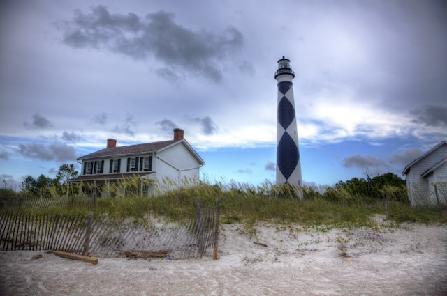
Finally, from offshore you can access Cape Lookout National Seashore. There are no facilities, but the large anchorage is good in the prevailing winds and you can land your dinghy anywhere on the expansive beaches. There’s miles of walking, incredible sea life and shelling, and stunning vistas of the iconic diamond-studded lighthouse. It’s best saved for the best weather, but the inlet in and out of the anchorage (Lookout Bight) is wide and deep.
North Carolina’s Intracoastal Waterway
After the Neuse River and the little town of Oriental, the Intracoastal passes through a man-made cut to get to the coast at Beaufort and Morehead City. From this point south, the ICW feels more like South Carolina and even a little like Florida. It’s a narrow, shoaly channel that cuts through shallow bays and sounds just inside the beachy barrier islands.
Navigating the NC ICW is tricky due to the very sandy bottom and strong currents around cuts and inlets. Many inlets between barrier islands are not navigable — they are too shallow and the sand shifts too readily. Even just keeping your boat in a well-marked channel can be tricky, with strong currents from the inlets pushing or pulling the boat. Anywhere the channel crosses an inlet channel, will be home to a trouble spot.
Hot spots along the path that you want to watch out for include where the ICW passes the following inlets. These spots have frequent dredging, moving markers, and frequent vessel groundings.
- Bogue Inlet
- New River Inlet
- Topsail Inlet
- Mason Inlet
- Carolina Beach Inlet
- Lockwoods Folly Inlet
- Shallotte Inlet
To help navigate these areas, it’s highly recommended that you use the Aqua Map app with US ACE surveys activated and Bob423’s tracks turned on.
North Carolina Marinas and Anchorages
There are plenty of marinas in North Carolina for every taste. Many are filled with sport fishing boats, especially near inlets that lead offshore. Transient accommodations along the waterway are easy to come by. The farther you venture off the ICW, the cheaper the slips become.
Moorings are not common here, so most anchoring areas are open. In tight spaces, you will occasionally find liveaboards and derelict vessels clogging up the works. Along the ICW, you may want to use two anchors in a Bahama mooring to limit your swing with reversing currents.
Navigation Notes for North Carolina
Between Norfolk and Beaufort, none of the inlets that pass between the Outer Banks islands are considered navigable without local knowledge. Some of them (Oregon Inlet, for example) are notoriously dangerous. Ocracoke Inlet has no bridge and is regularly surveyed. Still, it is a very tricky, shoaly, and current-filled area that even local cruising boats should only attempt in totally calm weather.
This means boats traveling south must choose their route, since there is no way to hop in and out between Norfolk and Beaufort. You must either go outside (and stay there) or stay inside on the ICW the entire way between the two. For slow boats, that means a one or two night passage. As with other sections of the ICW, bridges limit boats to 65′ — but high water from rains and older bridges makes it closer to 64′. There are two troublemaking bridges along the way, the Wilkerson Bridge on the Alligator-Pungo Canal, and the Pungo Ferry bridge on the Virginia Cut. Both occasionally have less than 65′ clearances, and neither has regular tides. Tides here are wind driven, and water levels occasionally rise from rainfall.

Once you’re south of Beaufort/Morehead City, day hops offshore become a viable option for all boats with suitable inlets spaced perfectly for knocking off miles when the weather is good. You can leave Beaufort in the morning, arrive in Wrightsville Beach at sunset, stay the night, and then spend the next day taking the ICW shortcut to the Cape Fear River. From there, it’s another day hop offshore to Winyah Bay in South Carolina.
The ICW shortcut here is an excellent time-saver because Fry Pan Shoals extends so far offshore, making a day hop unlikely. However, staying well offshore, we have overnighted from Beaufort to Winyah Bay and around the shoals. There are many options in this part of the world, but working south against the prevailing winds requires patience and careful weather timing.
The state’s Class A inlets are Beaufort/Morehead City and the Cape Fear River at Southport. Other suitable inlets that are usually easy to navigate include Masonboro at Wrightsville Beach and the Little River Inlet at the state line (Myrtle Beach).
If you’re new to using the inlets along the Southeast Coast, be sure to study the dos and don’ts for a smooth passage.
North Carolina Tides and Currents
Like navigation, tides and currents change when you move between the sounds, rivers, and coastal areas.
Sounds and Rivers Region Tides and Currents
This area experiences practically zero tidal change throughout the day, but some locations see dramatic changes with wind-driven tides. Currents are similarly unpredictable. Heavy rains can cause the rivers to ebb strongly, but the water movement caused by wind-driven tides can also create a surprise knot or so of current in either direction.
North Carolina ICW Tides and Currents
Once you’re along the coast, currents and tides increase dramatically. Average tides in the Beaufort/Morehead City area are only about four feet, but currents in the inlet are regularly 2.5 knots or more.
Tides get higher, and currents get stronger the farther west you travel. The Cape Fear River has a fierce current on the ebb tide — sometimes more than 4 knots! The ICW follows the river for about five miles, where you want to ensure the wind is not opposing the tide, and where you want the current in your favor if you’re a slow boat.
Boating Weather in North Carolina
Summer boating weather is hot and still with afternoon thunderstorms that move east off the mainland.
North Carolina is not a safe refuge from hurricane season. The state has a few storms every season, with a higher likelihood the farther east you travel. The Outer Banks are regularly scarred by storms each year. A typical path for storms takes them out of the Atlantic and arcing toward the northeast, but when and where they make the turn makes or breaks it for North Carolina. Most stay well offshore, some skirt the Outer Banks, and some make a direct landfall on the coast and track north toward Chesapeake Bay.
Unfortunately, the lowlands of NC do not slow storms down much once they make landfall. The area’s wind-driven tides mean that storm flooding along the sounds and rivers is common. When Hurricane Florence made landfall near Wrightsville Beach in 2018, New Bern (well north and far inland) experienced a devastating 10.5-foot storm surge. Several marinas were destroyed, and it took the town months to rebuild.

Regular cold fronts mark spring and autumn weather. The state’s location near the jet stream (upper-level winds) and Gulf Stream (warm ocean current) creates exciting weather patterns, including bomb cyclones that become powerful Nor’easters just offshore. In the right conditions, the weather can deteriorate rapidly in Eastern North Carolina, and winds can quickly become surprisingly strong.
North Carolina is a year-round boating location, and most people here do not haul their boats out for the winter. Still, cold snaps regularly dip below freezing, so being on top of your winterization is essential if you leave your boat here. Some marinas shut off the water for the season, but those with liveaboards simply turn the water on and off as the weather demands. Many people do liveaboard year-round here.
Special Notes About Boating in North Carolina
Government, Aqua Map, and Navionics charts are generally accurate throughout the state. The exception is at shifting channels, where the best information comes from USACE (Army Corps of Engineers) surveys. These are readily available on the Aqua Map boating app with a Master subscription — well worth the cost if you transit these areas.
The surveys remove the mystery from places like Ocracoke, where even the ferry occasionally runs aground. Best of all, the app provides the date of the survey, so you can easily verify how current your best information is.
The sounds and rivers are often littered with crab pots, both outside and along the center of the channel. Be sure to review your fishing gear before setting out to know what to expect.
North Carolina Boating Places of Interest
There’s too much to explore in North Carolina to list here. But here are some of the significant cruiser ports of call along the way, and then some of the little places you really don’t want to miss.
Major Ports and Cruiser Hangouts

- Belhaven — A small town that has a great location to stop for the night when cruising the ICW.
- Oriental — The “sailing capital of North Carolina,” it’s situated at the mouth of the Neuse River just inland of Beaufort.
- New Bern — Off the ICW, but a major hub for boaters with its downtown marina.
- Beaufort — Located at the first Class A inlet after coming from Chesapeake Bay, this little coastal town is a popular stop for ICW cruisers and offshore voyagers. Its position inside Cape Hatteras makes it a great jump-off point for points south, like trips to the Bahamas or even the Caribbean.
- Wrightsville Beach/Carolina Beach — Wrightsville is the beach town suburb of Wilmington, a major city in the region. There are several big marinas and anchoring options. Carolina Beach is just a few miles away and welcomes
- Southport — Small town at the mouth of the Cape Fear River, about 30 miles north of the state line.
Cute Places in NC You Ought to Visit by Boat

- Dismal Swamp Canal & Elizabeth City—Be sure to research whether you should take the Dismal Swamp route. For some, it is a bucket-list-worthy alternative to the regular ICW. A fun local trip is to make a loop, going up the Dismal Swamp to Norfolk/Portsmouth and then back south through the Virginia Cut on the regular ICW.
- Manteo, Ocracoke, and Outer Banks — See the discussion above about the Outer Banks.
- Inner Banks: Washington and New Bern—These towns require traveling off the ICW, so they see less traffic. But they’re totally worth the detour.
- ICW Norfolk to Beaufort including Belhaven and Oriental
- Cape Lookout National Seashore — Easily accessible (for boaters) and isolated location at the southern end of the Outer Banks. Anchor at the foot of a beautiful lighthouse and walk miles on a shell-strewn beach. It doesn’t get much better!
- Carolina Beach — Fun beach town with several marinas, town moorings, anchoring options, and two dinghy docks.
- Wilmington — Major city up the Cape Fear River with marinas right downtown.
- Bald Head Island — Small golf cart community at the mouth of the Cape Fear, beautiful beaches and a welcoming marina.
North Carolina Boating Special Events
Albemarle Loop
It’s not an event, but local businesses have teamed up to encourage cruisers to spend a little time adventuring off the ICW. The Albemarle Loop is really just a collection of towns and marinas around Albemarle Sound that offer one or two free nights stay to encourage visitors to their little towns.
The free docks usually lack water and power, but visiting some of these little places that few other boaters venture to see is neat.
Places to Get Boat Work Done
Southport, Morehead City, and Oriental are boating hubs, and several boatyards are in those towns. But there are plenty of others, too, small yards with reasonable rates. Some even allow DIY.
Catamaran Boatyards in North Carolina
Here are a few yards we know of that have wide travel and haul catamarans. As always, check each yard to see if they can take your beam!
- Jarret Bay Boatworks, Beaufort (huge lift, popular with big boats)
- Bridgeton Boatworks, New Bern
- TJ’s Marina and Boatyard, Belhaven
Resources, Guides, and More North Carolina Boating Information
Other Boat Life Academy Guides and Notes
Leave a Reply