There are tons of apps for boaters, but how many are really important to everyday life? If Dockwa wrote this article, we’d include Dockwa on this list; if BoatUS made it, we’d include their app. But this article isn’t written by anyone but a cruising boater, and while I have those apps on my phone, I rarely use them.
This is a list of boating apps useful for daily activities, such as navigating, researching, weather planning, etc. After trying many different apps, we’re pretty happy with the set we’re using right now. These are the ones worth your time and money.

Best Boating Apps for Blow-Boaters and Stink-Potters
Our tablets and smartphones have revolutionized the tools and information available in the cockpit of our sailboats. Today, one has to ask whether it’s worth having a real marine chartplotter when the apps are so good. For us, the only reason to keep the real chartplotter is the radar (but apps can provide AIS).
Here are the various apps we use for navigation, weather, destination research, and everyday life on the boat.
Aquamap
If we were piloting an airplane, we would refer to Aquamap as our “electronic flight bag.” For those of you who are pilots, Aquamap is the Foreflight of the marine world. It combines nearly everything you need: navigation, weather info, and planning tools. It stands out from the competition for a few reasons.

First, it has the best nautical charts around. The company works to find and (in some cases) create the best charts. Case in point: They worked directly with Explorer charts to convert their Bahamas chartbooks into electronic format. But if you still love the old chartbooks, the app lets you display either the Raster or ENC formats!
The company also took something once obscure and difficult to use: the US Army Corps of Engineers underwater depth surveys. These have been available online in PDF format through the Corps’ website for a long time.
Aquamap takes that data and displays it in on your chart, with your GPS position put on top. Now, a random, obscure government data source is available and much more useable. For shy sailors like me who do not like to touch bottom, this app can give you the confidence to poke around in places you might not have had the courage to go. Each survey includes the date it was taken, so you can easily see how old it is.
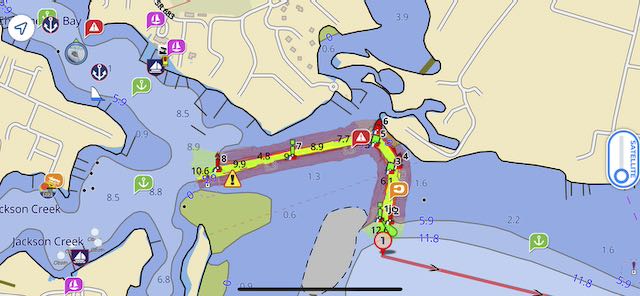
The attached picture is from Jackson Creek in Deltaville, VA, and shows the channel in a way that the normal charts do not. During the one week we were there in 2024, we watched at least five boats go around in this channel, so having a little extra help could have benefited someone.
The Corps surveys are available for most major port areas, including inlets, where commercial shipping transits. It’s also available at a handful of other spots, like some trouble areas on the ICW where people continually have issues.
But that’s only the beginning of the great features this app has. It also has the following:
- Waterway Guide and Active Captain information points (no memberships required to view). WG includes frequently updated fuel prices and some dock prices.
- Easy slide to overlay satellite images.
- Coast Guard local notice to mariners (LNM) and light list details.
- Route planning tools.
- View and updating of Bob423 tracks for the ICW route.
- Excellent anchor alarm tool (the best I’ve found).
- Weather forecasts (including NWS marine zone forecasts) and buoy reports.
- Tides and currents predictions.
- If you have NMEA2000 over WiFi on your boat, the app will show instrument data and AIS traffic.
- Live position sharing and member profiles.
- Maps are downloaded locally to your device, so you don’t have to have an internet connection to use the app.
The cost of Aquamap depends on which charts and features you want to use. At the moment, we keep three subscriptions active:
- Master subscription (required for USACOE surveys and AIS/Wifi data), $24.99 a year
- North America charts (US and Canada), $14.99/year or $49.99/lifetime
- Bahamas Explorer charts, $49.99/year or $139.99/lifetime
Navionics Boating
Aquamaps is the clear choice for planning the boat’s route and chart plotting. However, I keep a Navionics subscription (app only) for one purpose: Sonar Charts.

Navionics sonar charts are crowd-sourced from people’s depth sounders, giving you a different data set from what other charts use. And while Aquamap has some crowd-sourced bathymetry like this, Navionics has collected data for years.
My big problem with Navionics sonar charts is that there is no way to check up on them. How old is the sounding, and did that person have their sounder calibrated in any way? What if they inaccurately reported their keel offset? So, in the end, you have to take it with a grain of salt — just another data point to consider. It certainly doesn’t carry the same weight as the professionally-made USACOE surveys you can get in Aquamap (but those aren’t available everywhere).
The Navionics app has other features, but we like the Aquamap app for every other purpose. We only open Navionics to compare the sonar chart data to the Aquamaps charts, whether sourced from NOAA in the US or Explorer in the Bahamas.
Navionics Boating requires a $49.99 annual subscription to get US and Canada charts. We’ve used it this year, but I’m not sure I’ll renew it.
Windy (windy.com)
Every boater needs a good weather app (and there are plenty to choose from), but we’re very pleased with windy.com. Note: There are two windy apps (windy.com and windy.app), and we’re referencing the first, whose icon and logo are red.

The features of this weather app are mind-boggling, and we use it for everything. Here are the major tasks we use it for regularly on the boat. (The app can do a ton more than this, though.)
- Weather and wind reports from airports and some marine buoys.
- Weather radar, satellite, and lightning strikes to show actual precipitation.
- Wind forecasts from seven different weather models, including the big ones (Euro, GFS, NAM, etc.).
- Wave and swell forecasts (combined or separated into swells and wind waves).
- Sea surface temperatures.
- Currents (Gulf Stream forecasts).
- Rain and thunder forecast for various models.
- Thunderstorm risk and CAPE index.
- Fog and low clouds.
- Tropical system monitoring.
- Upper-level wind forecasts to provide longer-term forecasts.
You don’t need it, but we have purchased the annual subscription for $18.99 a year to get longer-range and hourly forecasts.
The premium also includes a simple route planner, allowing you to draw a route, set your speed in knots, and see the weather change as you progress. It’s not smart enough to correct your speed for different conditions (like PredictWind does), but we find it does a fine job of letting us see if adverse winds will affect us.
Noforeignland

Norforeignland has become one of our favorite apps. It’s primarily a social network of long-term, long-distance cruisers — mostly sailors but plenty of motor yachts. The app allows you to set up a profile for yourself and your vessel and position the vessel however you like. You can manually update your position when you get to a new anchorage, or there are plenty of ways to have the app record your track during a passage and upload it to the site.
My favorite feature of the Noforeignland app is the “show my journey” page, which displays a map of your boat’s tracks from whenever you joined. We went one step further and added our tracks from our old Garmin InReach, so Noforeignland now shows pretty much everywhere we have taken this boat. You can do custom calculations to figure out how many miles you’ve gone this month or this year, and you can edit the track to make it more accurate (helpful if you made a point-to-point track and it passes over land instead of around it). You can also add photos and stories to turn it into a map scrapbook of sorts.
If you have Starlink on your boat and Noforeignland actively tracking your position, you can track your position in real-time at no extra cost.
I also love that the app has a truly global reach. It’s amazing to follow cruisers on the other side of the globe and see what facilities are available when daydreaming of cruising the South Pacific or Northern Europe.
The app also has some of the best information specifically tailored for boaters. Members add icons to the map, and there are many more icons than WG or Active Captain has. For example, there are specific icons for dinghy docks, propane refill stations, pump outs, laundromats, trash cans, mechanics, dive spots, and dog parks — things you must dig for on other platforms. Each icon location can include reviews and photos (another thing sorely missing on other platforms).
Finally, the app allows you to follow your friends’ boats and receive updates on their movements. It also has a blog and forum for discussions.
Noforeignland is free, but there is a Patreon to support the cruisers who created and maintain it.
Google Maps

Google isn’t necessarily a boating-specific app, but we still use it daily for boating. First, it’s the easiest place to find nearby businesses in a new town, such as restaurants, hardware stores, and groceries. The reviews also tend to be helpful.
Secondly, I love the satellite view. I like to research places I’m going in advance, especially cozy anchorages or marinas. I will always look at new marinas to determine where the fuel dock is and plan my approach before I get there. In anchorages, I compare what I can see on satellite to the charts and look for nearby things of interest: sandbars for the dog, boat ramps or dinghy docks for walking, and nearby stores or restaurants I might be able to get to. Even if I don’t plan on using these things, I always look. Partly out of curiosity, but also for safety: If someone had a medical emergency at night, how easy would it be to get them ashore?
Google Maps is a free app.
Bonus Apps: Ride Shares and Delivery Services
Uber, Uber Eats, Instacart, DoorDash, and Walmart are not boater-specific, but we’ve started using them more and more to do chores on our boat.
It’s nice to know you can use Uber to make a shopping run in a city. Better yet, have Instacart or Walmart bring you a huge provisioning run.
These apps have their share of problems: wrong orders, lost orders, and bad communication. But, more often than not, they’re revolutionary for boaters without cars. We’ll still walk for a few things at the supermarket when we can, but these apps mean you can get a month’s worth of groceries without renting a car or have your favorite restaurant meal delivered as a special treat.
Leave a Reply